Planet Earth in Cross Section
New Rochelle
High School, Westchester
Summer Research Program for Science Teachers
August 2010
Subject:
Earth Science
Objective: Students will construct a model of the interior of the Earth to scale using cash register tape
Materials:
- Cash register tape
- Meter sticks
- Colored pencils
- Calculators
- Class notes: Earth's Interior
- Earth's Interior Worksheet #1
- Earth's Interior Worksheet #2
- Earth Science Reference Table - Page 10
Introduction: Planet Earth is organized into layers of varying thickness. Earth is a solid, rocky planet that becomes denser as one travels into its interior. Gravity has caused the planet to differentiate, meaning that denser material have been pulled towards Earth’s center. Relatively less dense material migrates to the surface. What follows is a brief description of each layer beginning at the center of the Earth and working out towards and including the layers of the atmosphere.
Outer Core
–
A layer surrounding the inner core that
is about 2270 kilometers thick and which is a liquid.
Mantle
– A solid, 2885-kilometer thick layer of ultra-mafic rock located below the
crust. This is the thickest layer of the
earth.
Asthenosphere
– A partially
melted layer of ultra-mafic rock in the mantle situated below the lithosphere.
Tectonic plates slide along this layer.
Lithosphere
– The solid outer
portion of the Earth that is capable of movement.
The lithosphere is a rock layer composed of the crust (felsic
continental crust and mafic ocean crust) and the portion of the mafic upper
mantle situated above the asthenosphere.
Hydrosphere
–
Refers to the water
portion at or near Earth’s surface.
The hydrosphere is primarily composed of oceans, but also includes, lakes,
streams and groundwater.
Atmosphere
– The layer of gas
that surrounds our planet. Earth’s
atmosphere is composed primarily of nitrogen and is broken down into distinctive
layers based on temperature profiles.
Troposphere –
A 10 to 12-kilometer
layer of the atmosphere next to the earth’s surface in which
temperature generally decreases rapidly with altitude and clouds form.
Stratosphere –
The layer above the
troposphere in which temperature increases with an increase
in elevation. The
stratosphere contains the ozone layer.
Mesosphere –
The layer above the
stratosphere in which temperature decreases with altitude.
Thermosphere –
The outermost layer of
the atmosphere located above the mesosphere.
In this layer, temperature rapidly increases with altitude.
Procedure: In this lab a model of the layers of the earth will be constructed to scale using cash register tape. The tape will represent a “column” of the Earth from its center to the outermost portion of its atmosphere.
This cross-section model will be constructed to a scale of 1 centimeter is equal to 100 kilometers (or 1:10,000,000). The ratio of 1 to 10,000,000 means that one unit of measure on a ruler is equal to 10,000,000 units of measure on a map or scale model. If there are 10,000,000 centimeters in 100 kilometers, then 1 centimeter is equivalent to 100 kilometers.
Note at this scale
one centimeter of register tape equals 100 kilometers
The average width of a line drawn by a sharp pencil varies from 0.05 to 0.08 cm.
Therefore the width of a pencil used to
draw layers will range in scale from 5 to 8 kilometers
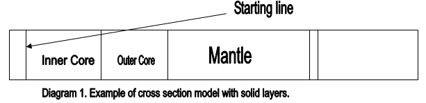
Take a 90 cm piece
of cash register tape and secure each end of the paper to the table top with a
piece of masking tape.
Use a ruler and neatly draw a line perpendicular
to the length of the tape roughly 10 centimeters from one end.
This will be the starting line for all
the layers. See diagram below.
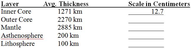
Calculate the scale distances for the solid
portion of the Earth and note it in the table below.
To
do this, divide the average thickness of a layer by 100 and round to the
nearest tenth. Follow this example:
The radius of the inner core is 1271km. Thus 1271/100 = equals a 12.7 cm thick layer drawn on the register tape. Note the scale distances for all the layers on the data table below.
Using a pencil measure mark off the layers of the Earth onto the register tape based on your calculations. Begin from the center of the earth and add each successive layer in order. Label each layer on the cash register tape.
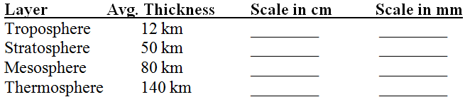
Calculate the scale distances for the atmosphere using the table below. Same procedure as # 3. Draw the layers of the atmosphere by marking the boundaries or “pauses.” Use the outer edge of the lithosphere as a starting point. You do not need to label these layers.
Refer to the background information in this lab and on your model, note the composition of the inner core, outer core, mantle, asthenosphere and lithosphere.
Refer to page 10 of the E.S.R.T. Note on the model the temperature of the Earth’s interior at 1000 km intervals.
Refer to page 10 of the E.S.R.T. Note on to the model the density ranges of the inner core, outer core and mantle.
Color the inner core yellow, the outer core orange,
the mantle red, the asthenosphere light brown and lightly pencil
shade the lithosphere. Color the
troposphere light blue the stratosphere pink, the mesosphere dark blue and
thermosphere violet. Color the
remaining space black.
Discussion Questions:
List the layers of the solid Earth from least dense to most dense (include density values).
What causes the layers of the Earth to be ordered by density?
Are all of the layers composed of the same materials? Which layer is the biggest?
Measure the entire length of the model that you made using a metric ruler (in cm). What is the radial thickness of the solid earth in kilometers on the model that you created?
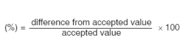
The actual radius of the Earth is 6,378 km. What is the percent error for the measurement from question #4? Show all work and circle the final answer.
Analyze the scale model and determine two or more possible sources of error assuming that the scale distances are correct.
Mount Everest is the tallest mountain on Earth, rising 8,850 meters above sea level. How high (in centimeters) would it appear to be on this scale model?
The average depth of the ocean is 4 kilometers. Describe where this would fit on the model (between which layers) and how thick would it be drawn on your model.
The Earth is approximately 40,000 kilometers in circumference. What percentage of the Earth’s circumference is represented by the width of the register tape?
Examine the model and determine the layer in which life on earth exists. Describe the thickness of this layer relative to the radius of the Earth.
New York State Standards - Physical Setting/Earth Science CORE Curriculum:
Standard 4
Students will
understand and apply scientific concepts, principles, and theories pertaining to
the physical setting.
Mathematical Analysis:
Key Idea 1
Standard 6
Students will
understand the relationship between mathematics and science by creating a model
that is made to scale of the layers of the Earth.
Models, Magnitude and Scale: Key Idea 3
Students will group
magnitudes density, temperature and pressures into a series of relative order
providing a useful way to deal with the immense range as they develop a cross
sectional scale model of the interior of the Earth.